Skip the tourist traps on the Pacific Coast Highway. We reveal the best routes, hidden stops, and local tips for a road trip that feels like yours.
- May 18, 2026
Why Everyone Gets the PCH Wrong (And How You Can Fix It)
You've seen the photos: a curve of asphalt hugging a cliff, the Pacific shimmering below, a convertible with the top down. The Pacific Coast Highway (PCH) is America's most iconic drive, but most people treat it like a checklist. They rush from Big Sur to Santa Monica, snapping the same pictures as everyone else, then wonder why it felt like a blur of traffic and overpriced clam chowder.
The truth is, the PCH isn't one road—it's a collection of distinct regions, each with its own rhythm and hidden corners. The stretch from San Francisco to San Diego covers roughly 600 miles, but the best experiences don't come from covering distance. They come from knowing where to pause, when to detour, and which overlooks are actually worth your time. This isn't a guide to seeing everything. It's a guide to seeing what matters.
Here's the honest take: the PCH can be frustrating. Fog can roll in and erase the view in minutes. A single RV going 15 mph can test your patience. But when you plan for those realities instead of fighting them, the road becomes something better than a postcard. It becomes a real adventure.
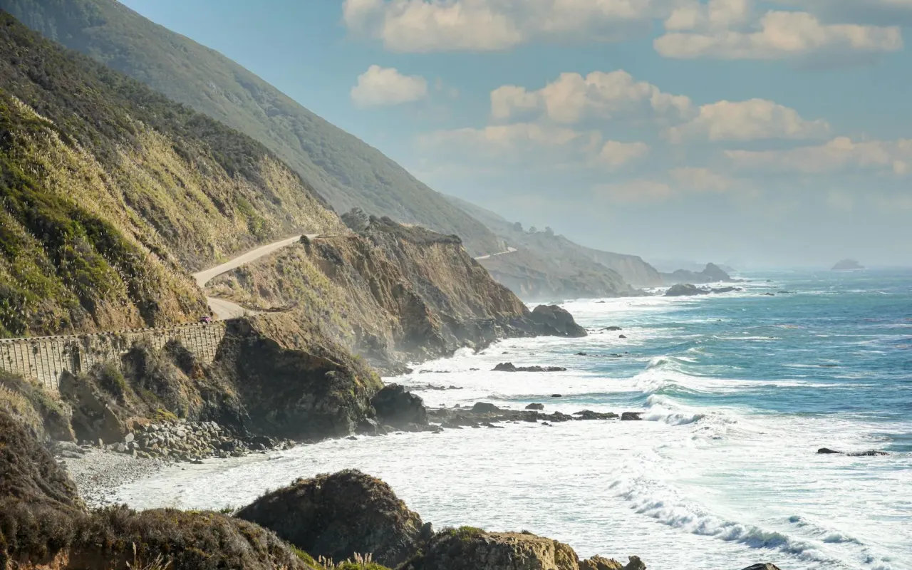
The Northern Gateway: San Francisco to Monterey (The Foggy, Moody Start)
Most people start in San Francisco and gun it straight for Big Sur. That's a mistake. The 120-mile stretch from the Golden Gate Bridge to Monterey is a moody, coastal masterpiece that deserves its own day. You're leaving the city behind, crossing the bridge, and immediately hitting Highway 1 through Pacifica and Half Moon Bay. The fog here isn't a problem—it's the feature. It softens the edges of the cliffs and makes the cypress trees look like they're from a gothic novel.
Your first real stop should be Pigeon Point Light Station, about 45 minutes south of San Francisco. It's a 115-foot lighthouse that's been standing since 1872. Skip the visitor center—park at the pullout just past it, walk to the fence, and look down at the elephant seals lounging on the beach below. They're there year-round, and watching them flop around in the surf is oddly meditative. There's no entrance fee, and you'll have the spot mostly to yourself if you arrive before 10 a.m.
From there, continue to Santa Cruz, but don't just hit the boardwalk. Take a detour to Natural Bridges State Beach, where a massive sandstone arch frames the ocean. It's a 10-minute walk from the parking lot, and the tide pools at the base are full of purple sea stars and hermit crabs. If you're hungry, stop at The Penny Ice Creamery for a scoop of sea salt caramel—it's the kind of small-batch stuff that makes you forget fast food exists. The key here is to avoid the Monterey-bound rush by leaving Santa Cruz by 2 p.m. Traffic builds up fast on the two-lane road, and you don't want to be stuck behind a tour bus at sunset.
Where to Stay and Eat: The Local's Choice
Monterey is overrun with chain hotels, but the Monterey Bay Inn on Cannery Row offers water views without the resort markup. Book a room facing the bay, and you'll wake up to sea otters floating in the kelp beds. For dinner, skip the tourist-heavy restaurants on the Row and drive five minutes to Pezzo's Pizza in Pacific Grove. Their "Cannery Row" pie with artichokes, sundried tomatoes, and feta is a local secret. One slice will cost you less than a bowl of chowder, and it's twice as satisfying.
Big Sur: The 90-Mile Stretch That Demands Respect (and a Full Tank)
Big Sur is the crown jewel of the PCH, and it's also the most unforgiving. There are no gas stations between Carmel and Cambria for 90 miles. No cell service in many spots. And the road is narrow, winding, and often closed for landslides. That's not meant to scare you—it's meant to prepare you. The rewards are staggering: sheer cliffs dropping into turquoise water, redwood groves that smell like rain, and views that make you forget your phone exists.
Your first must-stop is Bixby Creek Bridge, the iconic concrete arch you've seen in a thousand Instagram posts. But here's the trick: don't stop at the main pullout. Continue south about a mile to the Hurricane Point Vista Point. It's less crowded, and the angle captures the bridge with the full sweep of the coast behind it. Arrive by 8 a.m. to beat the tour vans, and you'll have the place to yourself for a solid 15 minutes.
Further south, Pfeiffer Beach is a hidden gem that's easy to miss. The entrance is unmarked on Highway 1—look for a small sign on the west side of the road, just past the Big Sur Station. The road down is narrow and unpaved, but it leads to a beach with purple sand (yes, purple—from manganese garnet deposits) and a natural rock arch called Keyhole Rock. Go at low tide, and you can walk through the arch to a secluded cove. Parking is $10 cash only, and the lot fills up by 10 a.m., so plan accordingly.
For a break from the car, hike the Pfeiffer Falls Trail in Julia Pfeiffer Burns State Park. It's a short, 1.5-mile loop through redwoods that ends at a 60-foot waterfall cascading directly onto the beach. The trail is well-maintained and mostly shaded, making it a perfect midday escape. Bring water—there's nowhere to buy it once you're on the road.
The Practical Reality of Big Sur
Gas up in Carmel before you start. The only station in Big Sur is at the Big Sur River Inn, and it charges a premium. Also, check Caltrans' website for road closures before you go—landslides are common after rain, and detours can add hours. If you're doing the drive in one day, leave Carmel by 7 a.m., take your time, and expect to reach Cambria by late afternoon. That gives you enough daylight to enjoy the stops without rushing.
San Luis Obispo County: The Quiet Coast Most People Miss
After the drama of Big Sur, the coast mellows out as you enter San Luis Obispo County. This is the stretch from Cambria to Pismo Beach, and it's where the PCH becomes a small-town road. The cliffs give way to rolling hills, cattle ranches, and beaches that feel like they belong to a quieter era. Most tourists blast through this section on their way to Los Angeles, but that's a mistake. This is where you can actually breathe.
Hearst Castle in San Simeon is the obvious draw, but skip the $30 tour if you're on a budget. Instead, drive up to the Hearst Memorial Beach just north of the castle. It's free, uncrowded, and offers a perfect view of the coastline. The waves here are gentle, making it a good spot for a quick swim or a picnic. Bring your own food—the only option nearby is a gas station with sad sandwiches.
Further south, Morro Bay is worth a stop for the volcanic rock formation that rises 576 feet out of the water. The town itself is a working fishing village, and the Morro Bay State Park has a boardwalk that winds through the estuary. Rent a kayak for $30 from Kayak Horizons and paddle out to the rock—you'll see sea otters, harbor seals, and maybe even a migrating whale if you're lucky. The water is calm, and the experience costs a fraction of a whale-watching tour.
End your day in Pismo Beach, a classic California beach town that hasn't been overrun by chain stores. The pier is a great spot for sunset, and the Splash Cafe serves clam chowder that actually lives up to the hype—get it in a sourdough bread bowl. If you're staying overnight, the Pismo Lighthouse Suites offers rooms with ocean views starting at $150 a night, which is a steal compared to Monterey prices.
Santa Barbara to Malibu: The Glamorous, Traffic-Heavy Finale
This is the stretch of the PCH that most people imagine: palm trees, white sand, and expensive cars. But it's also the most congested. From Santa Barbara to Malibu, the highway narrows to two lanes, and traffic can crawl on summer weekends. The trick is to treat this section like a series of destinations rather than a continuous drive. Pick two or three spots and commit to them.
Start in Santa Barbara, but skip State Street's tourist shops. Instead, head to East Beach, a quieter stretch of sand where locals play volleyball and the crowds thin out after 4 p.m. The Santa Barbara County Courthouse is worth a 30-minute detour—climb the clock tower for a 360-degree view of the city and the Channel Islands. It's free, and the architecture is straight out of a Spanish mission.
As you drive south, Ventura is a hidden gem that most people bypass. The Ventura Pier is one of the oldest wooden piers in California, and the San Buenaventura Mission is a peaceful stop with a beautiful garden. Grab a burrito at Taqueria Tepatitlan—it's a hole-in-the-wall with $8 burritos that are bigger than your head. Eat on the pier and watch the surfers.
The final stretch into Malibu is where the traffic gets real. If you're not staying overnight, time your arrival for late morning—before 11 a.m. on weekdays, the road is manageable. Stop at El Matador State Beach, a small cove with sea caves and rock formations that feel otherworldly. It's a 15-minute walk down the cliffs, and the parking lot only holds 20 cars, so arrive early. This is the beach you'll remember, not the crowded sands of Santa Monica.
The Final Word: Drive Your Own Road
The Pacific Coast Highway isn't a race. It's a collection of moments: the smell of salt and redwoods, the sound of waves crashing against rocks, the feeling of rounding a corner and seeing the ocean stretch to the horizon. The routes I've shared are starting points, not rules. If you see a dirt road that looks interesting, take it. If a beach is empty, pull over. The best discoveries on the PCH are the ones you make yourself.
Here's the one piece of advice I'll insist on: drive southbound. The Pacific Ocean will be on your right, and you'll have the best views without crossing traffic. Start early, bring snacks, and leave your expectations at home. The road will give you exactly what you need—if you let it.